TRAIL MAPS
Downloadable/printer-friendly maps and interactive web maps with information on trail use guidelines and restrictions.

The Tahoe Rim Trail Association is a community of volunteers and members committed to enhancing and preserving one of the most spectacular trails in the world.

Downloadable/printer-friendly maps and interactive web maps with information on trail use guidelines and restrictions.

Info on water sources, camping areas, required permits, shuttles, parking and more.
Our annual peer-to-peer fundraiser, Raise the Rim, is right around the corner! Get ready to get outside this August & mobilize your network to support the Tahoe Rim Trail!
Sign up by July 31 to win a 4 week membership with gear rental at Blue Granite Climbing gym!
The Tahoe Rim Trail Association is joining trail, recreation, and conservation partners across the country in urging Congress to reauthorize the National Parks and Public Land Legacy Restoration Fund.
Learn more on our blog.
Join the team behind the Tahoe Rim Trail. The TRTA is currently seeking a Development Director to lead fundraising, donor engagement, and revenue development efforts that support the long-term sustainability of the organization and the trail system we steward.
From mugs and picnic blankets to TRT apparel this is the one stop shop for all your Tahoe Rim Trail Association gear!
Have you been on the TRT recently? Help us keep trail users informed! Whether you encountered fallen trees, washed out trail, or muddy sections, your observations make a big difference. Submit a Trail Condition Report to help the TRTA and fellow trail users stay up to date on what’s happening across the trail.
With the help and collaboration from our friends at the Tahoe Institute for Natural Science, we are excited to offer options for youth ages 12-17 to explore the Tahoe Rim Trail with the inspiration and support from our trained backcountry instructors.
Beginning with the 2026 trail season there will be 10 Desolation Wilderness permits available to TRT thru-hikers per day to be obtained via recreation.gov. Desolation Wilderness is one of the most visited wilderness areas in the US and this change to permits is being made to protect its wilderness character for generations to come.
The Mission of the Tahoe Rim Trail Association is to maintain and enhance the Tahoe Rim Trail system, practice and inspire stewardship, and preserve access to the natural beauty of the Lake Tahoe region.

Whether tackling the Tahoe Rim Trail as a 165 mile thru hike or enjoying a leisurely day hike, the amazing vistas, high alpine lakes, meadows and peaks always make for a rewarding experience.
Hit the trail on a guided hike or head out on your own day hike or backpacking trip.
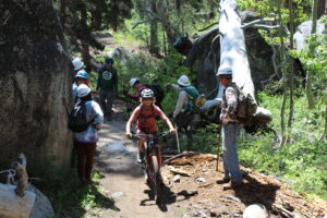
The Tahoe Rim Trail is an incredibly scenic and diverse mountain bike trail system. Grueling climbs, mellow non-technical trails, and hair-raising downhills can all be found on the Tahoe Rim Trail.
Before heading out, make sure to check out local regulations as some portions of the trail, such as designated wilderness areas, aren’t open to bikes.
 Experiencing the Tahoe Rim Trail on Horseback
The Tahoe Rim Trail is home to unforgettable memories for equestrians. Some segments present significant challenges so it’s highly recommended that all riders and their livestock have adequate trail experience.
Post with #tahoerimtrail and we'll share our favorites!
This site is protected by reCAPTCHA and the Google Privacy Policy and Terms of Service apply.
Crew Leaders | Guides | Board

