
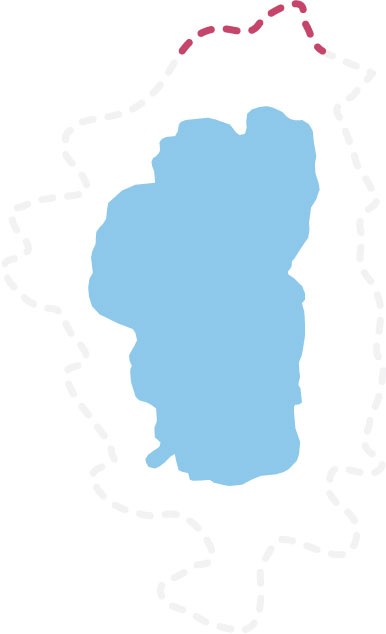
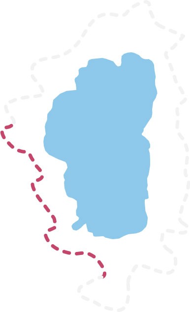
Barker Pass North – June 23, 2026
Gear Up & Get Out There!
Updated June 30, 2026
The Tahoe Rim Trail is now nearly completely clear of snow with some north & east facing slopes still holding onto some patches.
Expect:
- Small patches of snow at higher elevations and shaded areas
- Soft, wet, slushy, or muddy conditions during warmer parts of the day
- Standing water, running meltwater, and flooded sections in low spots or poor-drainage areas
- Rapidly changing conditions throughout the week as temperatures warm
- Additional rain or snow is always a possibility throughout the season.
Traction devices and trekking poles may be helpful in snowy, icy, or variable conditions. Waterproof footwear and extra layers are recommended during spring weather patterns. Be prepared for changing surfaces throughout your outing.
Before heading out, check current weather forecasts and recent observations, and be ready to adjust your plans based on conditions encountered on the ground. Let someone know your plans and carry extra food, water, and layers.
Spring on the Tahoe Rim Trail often brings snow, mud, runoff, and dry trail in the same outing. Flexibility and preparation go a long way this time of year.
Submit Trail Updates:
We’re actively gathering updates from the community and our partners. If you’ve encountered new conditions—like downed trees, snowfields, or trail blockages—please let us know here.
***NOTICE: As of January 1, 2024, bear proofing of all smellables (food, hygiene products, etc.) in a canister designed to prevent access by bears is required in all areas of the Tahoe Rim Trail. The TRTA has bear cannisters available for rental, call us to reserve yours today! (775) 298-4485
Jump To A Trail Segment, Or Scroll Down For All Segments:
Tahoe City North to Brockway West
Brockway East to Mt. Rose
Tahoe Meadows to Spooner North
Spooner South to Kingsbury North
Kingsbury North to Kingsbury South
Kingsbury South to Big Meadow Trailhead
Big Meadow Trailhead to Echo Summit
Echo Lakes to Barker Pass
Barker Pass to Tahoe City South
Trail Segment Conditions
Tahoe City to Brockway
Last Updated: 6/24/26

Trail Conditions
This section is now completely free of snow!
Tahoe City SNOTEL data is available here.
Water Sources
Water is available at Watson Lake, but it should be carefully treated before consumption. Watson Creek is flowing.
Parking and Access
64 Acres trailhead is plowed during winter months. The gate to access the Fiberboard Freeway is open as of 6/5/26.
Special Consideration for Overnight Trail Users
The dispersed camping area at Watson Lake is scheduled to close November 15; no campground water or trash will be available after that date.
Brockway Summit to Mt. Rose Summit
Last Updated: 6/24/26
Trail Conditions
Expect lingering snow in higher elevation areas along with muddy or wet trail surfaces during spring melt. Snow coverage may be more consistent on shaded slopes and in forested sections. Conditions vary throughout the day depending on sun exposure and temperature.
Mt. Rose Ski Area SNOTEL data is available here.
Water Sources
Water is available at Mud Lake (seasonal), Gray Lake, Frog Pond, and Galena Falls. Accessing some of these locations requires leaving the Tahoe Rim Trail and hiking downhill for up to a mile.
Parking and Access
Mt. Rose Trailhead parking remains open at this time. Tahoe Meadows parking is now open. Limited highway parking is available year-round.
Trail Use Regulations
Mountain bikes are PROHIBITED within the Mount Rose Wilderness. Mountain bikes and equestrians should take the forest road from Mt. Rose Summit trailhead to Relay Peak as ONLY hikers are allowed on the waterfall trail from Mt. Rose Summit trailhead to Relay Peak. Following these regulations helps prevent user conflicts. Please visit our Regulations and Permits page for more information.
Special Consideration for Overnight Trail Users
The Mount Rose Summit Campground is scheduled to be open for reservations from June 24 through September 10, depending on snow and other conditions. First come, first serve use is scheduled to start June 10. For more details, visit recreation.gov.
Tahoe Meadows to Spooner Summit
Last Updated: 6/24/26
Trail Conditions
This section is now clear of snow. Conditions vary throughout the day depending on sun exposure and temperature.
Marlette Lake SNOTEL data is available here.
Water Sources
Reliable water can be found in Ophir Creek, the Marlette Pump at the campground (pump is RUNNING as of 5/28/26), off the TRT at Marlette Lake, along the Marlette Lake Outlet, at Spooner Lake, and at the bathrooms at the Spooner Lake Visitor’s Center.
Parking and Access
The Tahoe Meadows trailhead parking lot & restrooms are now open! There is also limited parking along the highway shoulder.
Trail Use Regulations
Bikers are advised to ride on the TRT ONLY on even-numbered calendar days between Tahoe Meadows (Mt. Rose Highway/431) and Tunnel Creek Road. Bikers are PROHIBITED from riding the TRT between Hobart Road and Spooner Summit. Bikers are PROHIBITED from riding Christopher’s Loop because the trail is steep and fragile. Following these regulations helps prevent user conflicts. Please visit Regulations and Permits for more information.
During the 2026 season several trails in the Spooner Lake Backcountry State Park will be CLOSED during construction hours (weekdays), these closures impact North Canyon Rd, Marlette Lake Trail, Marlette Creek Trail, Hobart Road, Malette Flume Trail South from Rock Slide, and more. For more information on closures please visit the NV State Parks website for more information.
Special Consideration for Overnight Trail Users
The Mount Rose Summit Campground is scheduled to be open for reservations from June 24 through September 10, depending on snow and other conditions. First come, first serve use is scheduled to start June 10. For more details, visit recreation.gov. Dispersed camping is PROHIBITED within the Lake Tahoe Nevada State Park (between Tunnel Creek and Spooner Summit). You must camp at a designated campsite. The only designated campground in the park on the TRT is the Marlette Peak Campground. There is no fee, and no reservations are required. Please visit Backpacking, Bikepacking, and Thruhiking for more information.
Spooner Summit to Kingsbury North
Last Updated: 6/24/26

Trail Conditions
This section of trail is free of snow.
Water Sources
This section has no reliable water sources. The bathrooms at the Kingsbury North trailhead are open throughout the year during daylight hours.
Parking and Access
Kingsbury North trailhead parking is open. Genoa Peak Road is scheduled to be open from June 1 – November 15.
Kingsbury North to Kingsbury South
Includes Daggett system trails (e.g. Van Sickle Connector Trail)
Last Updated: 6/24/26
Trail Conditions
This section of trail is now completely clear of snow with seasonal creeks running strong. Spring conditions can change quickly with temperature swings.
Water Sources
Water is available on the west side of Hwy 207 at Edgewood Creek and on the Van Sickle Connector Trail at the Van Sickle Waterfall, and at stream crossings below the TRT junction. There is no water on the eastern side of the Daggett Loop.
Parking and Access
Van Sickle Bi-State Park is now open for the season to vehicles from sunrise to sunset through October. The Park is open to pedestrians from sunrise to sunset year-round. Kingsbury North Trailhead restrooms are open year-round from dawn to dusk.
Special Consideration for Overnight Trail Users
Dispersed camping is prohibited within the Van Sickle Bi-State Park. Generally, due to this segment’s proximity to neighborhoods, roads, and trailheads, users should avoid camping.
Kingsbury South to Big Meadow
Last Updated: 6/24/26
Trail Conditions
The trail is now free of snow from the Kingsbury South trailhead to Star Lake. There is still several patches of snow between Star Lake and Freel Peak. Trail is clear of snow on either side of Star Lake and Freel Peak.
Heavenly Valley SNOTEL data available here
Horse Meadow SNOTEL data available here
Water Sources
Daggett Creek is flowing. Mott Canyon is flowing. Star Lake is a reliable water source. There will likely be springs in a couple of places between the Freel Saddle and Armstrong Pass, approximately 2 miles northeast of Armstrong Pass. Grass Lake Creek has reliable flow.
Parking and Access
Big Meadow trailhead gate is closed during winter months with the presence of snow and ice. There is limited parking available along Highway 89 at the Grass Lake Spur trailhead. Horse Meadows Road/US 051 is not plowed in the winter.
Trail Use Regulations
Bikers are PROHIBITED from riding the Freel Peak Trail. Following this regulation helps prevent erosion and other resource damage. Please visit the Regulations and Permits page for more information.
Overnight Trail Users
The Luther Pass Campground near the Big Meadow trailhead is scheduled to be open from May 25 – November, depending on weather and other factors.
Big Meadow to Echo Summit
Last Updated: 6/24/26

Trail Conditions
Variable spring conditions continue, including mud, pooled water, and wet crossings. Conditions can change rapidly with new weather and warming temperatures.
Carson Pass SNOTEL data is available here
Water Sources
There is water at Big Meadow Creek, Round Lake, Dardanelles Lake (off the TRT), Showers Lake, the Upper Truckee River at Meiss Meadow, the ponds at the Four Lakes region just north of Meiss Meadow (approximately a mile south of Showers Lake), the flower bowl north of Showers Lake, approximately 3 miles south of Echo Summit at the upper end of the Benwood Meadow feeder creek, and in the creek that feeds Benwood Meadow 1.5 miles south of Echo Summit. There is also a pond near Benwood Meadow on the residential trail.
Parking and Access
The main parking lot at Echo Summit (Adventure Mountain) charges an $8 concessionaire fee when open (currently closed). Limited parking is available outside the main lot. Sno Park parking lot is open year-round.
Trail Use Regulations
The TRT joins the Pacific Crest Trail from Meiss Meadow to Echo Lake and beyond. Bikers are PROHIBITED from riding or being walked on the PCT. Following this regulation helps prevent user conflicts (and hefty fines!). Please visit Regulations and Permits for more information.
Echo Lakes to Barker Pass
Last Updated: 6/24/26
Trail Conditions
Expect snow coverage in north facing and shaded areas. Where snow has melted, expect muddy trail, standing water, and soft surfaces. Conditions remain highly variable and may change quickly with additional storms or warm weather.
Echo Peak SNOTEL data is available here.
Water Sources
There are plenty of water sources from the southern border of Desolation Wilderness north to Middle Velma Lake. All lakes should be considered reliable. Seasonal Phipps Creek will likely flow in the spring through mid-summer. Water is also available at Richardson Lake and from springs and streams south of Barker Pass.
Parking and Access
Parking is extremely difficult at Echo Lakes. The TRTA recommends trail users park at Echo Sno Park. The road to the Echo Lakes trailhead is not plowed in the winter. The Echo Lakes water taxi is scheduled to be open from Memorial Day to Labor Day. Contact Echo Lakes Chalet for shuttle information. Barker Pass Road through Blackwood Canyon is open from spring to fall depending on snow. It is normally scheduled to open on June 15th.
Bayview trailhead is currently closed to vehicle traffic. Limited parking exists outside of the gate along Hwy 89. Use extreme caution. Please use the designated pedestrian bypass to travel through the parking area to the trailhead.
Trail Use Regulations
Bearproofing of all smellables (food, hygiene products, etc.) in a hard-sided canister designed to prevent access by bears is required in Desolation Wilderness per Forest Service Order No. 03-22-11.
This entire section is collocated with the Pacific Crest Trail. Bikers are PROHIBITED from riding or being walked on the PCT and from riding or being walked in Desolation Wilderness. Following this regulation helps prevent user conflicts (and hefty fines!). Please visit Regulations and Permits for more information.
Special Considerations for Overnight Trail Users
Camping is prohibited between Highway 50 and the Desolation Wilderness border. Once within Desolation Wilderness, overnight users must have a permit. See our Regulations & Permits page for details.
Barker Pass to Tahoe City (64 Acres)
Last Updated: 6/24/26

Trail Conditions
This section of trail is now largely free of snow. Expect to still see snow patches in shaded & north facing areas.
Ward Creek SNOTEL data is available here.
Water Sources
North Fork Blackwood Creek has water. There are several springs crossing the trail north of Barker Pass and south of Twin Peaks. Ward Creek is a reliable water source.
Parking and Access
64 Acres trailhead is open. Barker Pass Road through Blackwood Canyon is open from spring to fall, and closed in the winter depending on snowpack.
Trail Use Regulations
The TRT joins the Pacific Crest Trail heading south from Granite Chief Wilderness. Bikers are PROHIBITED from riding on the PCT and from riding in Granite Chief Wildernesses. Following this regulation helps prevent user conflicts (and hefty fines!). Please visit Regulations and Permits for more information.
Additional Resources:
- For information on joining the 165 Mile Club, click here.
- For information on fire restrictions in Lake Tahoe, click here.
- For information on backcountry motor vehicle use, visit this page.
- For information on USFS info on gate, trailhead, and road closures, click here.
- For information about mountain bike and e-bike regulations on the TRT, click here.
- For a listing of special upcoming trail events held on the TRT that may affect your trail experience, click here.
- For information about conditions on mountain bike trails that link to the TRT, visit the Tahoe Area Mountain Biking Association’s webpage.
- To hire to your own consultant to help with winter season activities and other activities, click here.
